The Nerdy Traveler

Menu
  • Home
  • About me
  • Nerdy Chronicles
    • Hiking
    • Discovering PH
    • Around the World
  • Featured
    • Insights
      • Hiking
      • Travel
      • Environmental Awareness
    • Open Climbs
    • News Log
  • Project 16/81
  • Milestones
  • Uncategorized

Thursday, August 25, 2016

Beyond Buruwisan: Undiscovered Falls of Siniloan, Laguna

By 
Laguna has been tagged as the Waterfall Capital of the Philippines due to numerous waterfalls that can be found in the province. Many of these have received special attention recently - Pagsanjan Falls, Majayjay Falls, Hulugan Falls, Buruwisan Falls to name a few.

Far more than these famous waterfalls of Laguna, there are hundred of untouched and undiscovered falls that are yet to be explored. This is an account of our trip to the less known falls in Siniloan, Laguna.

-----------
Since it was summer and also as a part of my birthday celebration, I invited my friends to go visit some waterfalls in Laguna. We weren't sure though on what falls to visit and being shocked by the impact of sudden flock of people in Hulugan Falls, we searched for those that are less visited, until we came across this post on the falls of Siniloan beyond Mt. Romelo and Buruwisan Falls. Without any hesitation, we decided to explore and take a look on these waterfalls.

I met my friends at 7-11 Quiapo and went to Raymond's bus terminal in Legarda. We took the first bus trip bound to Infanta, Quezon at around 2 AM and asked the driver to drop us off at Kilometer 19 Trekker Station. It was a three hour trip and interesting enough, the bus traverses the province of Quezon, Rizal and Laguna multiple times. There are stopovers in Pililia and Siniloan where you can buy foods and take refreshments.

After three hours, we reached the Trekker Station.
That little signage indicating you're on the right location. Trekker's Station.
Since this area is relatively less publicized, only a few hikers know this place. During our hike, we are the first group to arrive. The registration and guide assignment is done in the Trekker Station. We were welcomed by Nanay Gloria (if I'm not mistaken). According to her, the entire mountainous range of Siniloan is protected by the Department of Environment and Natural Resources and is supervised by the College of Forestry and Natural Resources of UP Los BaƱos. She told us that it is still suspected that several waterfalls exist in the area and until now, explorations are still conducted. Knowing that we are engineers, she shared a lot of things and insights as apparently, she has been one of the pioneer consultants of mining companies here in the Philippines. No wonder why one will see several books in the registration booth.
My buddies for this hike - Ivy and Louie. You prolly have seen them lol.
The guide fee depends on the number of falls that will be visited. Our original plan is to visit four falls - Hagdang Bato, Tulay na Bato, Asul na Talon and Kalawang Falls, but Nanay Gloria told us that Kalawang Falls is closed due to ownership jurisdiction issues. However, she suggested to replace it with Kabagan Falls, a relatively newly discovered falls in the area. We adhered to it and after assigning us guides, we headed our way to the trail jumpoff. The trail jumpoff is a few kilometers away and one should take a jeepney to get from there.

With Nanay Gloria and the guides before going to the trail jumpoff.
The usual sequence in visiting these falls is as follows - Asul na Talon, Kabagan Falls, Hagdang Bato Falls and lastly, Tulay na Bato Falls. The trail actually ends on the registration booth so one can try doing the reverse. The first part of the trail is relatively easy and flat.
The first part of the trail is relatively grassy and rocky.
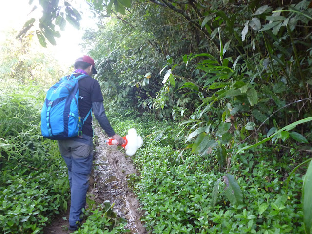
After crossing a cemented bridge, the trail gradually shifts. One should be prepared to river crossings as there are really several river crossings on the entire trail; hence, one should also expect that the trail is muddy and slippery. There are also moments where you will actually traverse the river, either on the shoulders or river itself, to go to your destination.
The blogger with Baymax on the trail. Muddy and slippery, isn't it?
We first reached an unnamed waterfalls after an hour of hiking. The locals did not consider it as a fall since this is more of an elevation drop in the river topography, as I would say. The height of the fall is only around three meters. Nevertheless, we gave this falls a name - Baymax Falls - in honor of Baymax. Hahaha!
A waterfall or not? 
From here, Asul na Talon can be reached in less than twenty minutes.
Baymax posing at Asul na Talon Falls.
The falls isn't blue at all, but the falls got its name because of a certain basin where its water flows.
The basin that gave that falls its name. You can really see how blue the water appears.
It might not be that obvious in this photo but the water in this basin really reflects a blue color. According to our guide, the reason why the water in this basin appears blue is that the basin is really really deep. He also told us that the depth of the basin is still unknown at this time and even though there were multiple attempts to determine it, all of them are unsuccessful.

It is in this falls also when we had our first encounter with limatik (leech).
Didn't expect that this trail will be this bloody. Blood from a limatik bite.
We weren't oriented that much that limatik are present in the entire trail. Nevertheless, it didn't stop us to enjoy the first of the four falls.
A curtain of water. Photo taken on one the small caves on the walls of Asul na Talon Falls.
After fifteen minutes, we continued our hike to the next destination - Kabagan Falls. The trail to this falls is the most difficult part of the trail, I would say since the falls is relatively new, opened to the public around January this year. The word kabagan actually refers to the river and cave that houses the falls so to get there, one should set foot on the cave first.

First time to see a centipede as big as this.
We reached Kabagan Cave after thirty minutes. One might notice a waterfall near the entrance of the cave but contrary to what many believes, our guide told us that this is not the Kabagan Falls yet. However, this is considered as a part of the Kabagan river-fall system.
Ivy and Louie taking a quick dip before going to the cave.

Kabagan Falls can only be seen upon entering the cave.
The entrance to the Kabagan Cave.

Blurred shot of the Kabagan Falls.
Extreme precaution is required since the cave houses several bats and the rocks are very slippery. Headlights are also required before entering the cave. One can also take a dip on the basin inside the cave but the water is really cold so better be prepared for it.

We then headed our way to our third destination - Hagdang Bato Falls. This is the most known falls on the vicinity. It took us an hour and a half until we reached Hagdang Bato Falls.
Laddered waterfalls. Water cascading through rocks.
As the name suggests, Hagdang Bato Falls is a waterfall cascading through rocks of different elevation, resembling a staircase. The water from this falls comes from a source different from that of Asul na Talon and Kabagan Falls. The current on this falls is very strong that one should really hold on to rocks to avoid being caught by the flowing water. The entire falls is wide and there are a lot of basins where you can take a dip and refresh yourself.
My buddies enjoying the gushing water of Hagdang Bato Falls.
Another curtain of water on the background. Signature chinito smile at Hagdang Bato Falls.
After enjoying the waters of Hagdang Bato Falls for thirty minutes, we set ourselves to the last part of the hike - Tulay na Bato Falls. It took us another thirty minutes to reach the waterfalls.
Stones and falls. The remnants of the former bridge can still be observed.
As the name suggests, there used to be a stone bridge in the falls, the remnants which can be seen until now. According to our guide, the stone bridge was built during the Japanese period. The purpose of the bridge is not yet clear; however, the bridge was destroyed by a typhoon. Along the trail to Tulay na Bato Falls, our guide pointed out a huge rock that according to him was a part of the bridge before.

The basin of this falls is large and is also deep, however, canyoneering is not advisable as per our guides.
Another limatik casualty.
After fifteen minutes, we headed our way back to the registration booth, marking the end of the hike. We took a bath at the booth and after settling our registration fees, we rode a jeep back to Siniloan to buy yema cakes and had our post climb dinner.

ITINERARY
SPECIAL NOTES
Transportation: To go to Siniloan, you can ride a bus going to Infanta at Raymond Bus Terminal in Legarda, Manila. First trip leaves at around 2 AM, with hourly trip intervals. Similarly, if coming from Laguna, Batangas, or Quezon, it is advisable to go to Sta. Cruz or Lucena and ride jeeps and buses going to Infanta. Drop off at Kilometer 19 or Trekker's Station. Fare from Manila to Kilometer 19 costs around Php 131 as of March 2016. 

For private transportation, drive along Marcos Highway. take the road to Siniloan, either traversing the Marcos Highway or Manila South Road. Upon reaching Siniloan, drive through the road that leads to Infanta.

Registration, guides and fees. The barangay hall strictl impose a no guide, no hike policy. Registration and environmental fees cost Php 30 per person. Guide fee depends on the number of falls to be visited - Php 600 per group of five if you intend to visit four falls. The guide fees are fixed.

Hiking and camping notes:

  1. The whole trail is infested with limatik or leeches. Prepare accordingly.
  2. The trail is muddy and slippery even on a sunny day. Several river crossings will be encountered on the trail.
  3. Cellphone signal is very weak across the whole trail.
  4. Hiking during rainy season is discouraged as the river can swell and might be impassable.
  5. Several water sources are available throughout the trail.

Estimated budget: Php 500 - Php 700

Overall rating of the hike: 8/10. Mostly because the falls are relatively unexplored and untouched.

Credits to Ivy Cadalzo and Louie Bedes for the photos.


Email ThisBlogThis!Share to XShare to Facebook
Newer Post Older Post Home

About the blog

On seas, summits, rivers, mountains and different destinations across the world. This blog narrates the stories and experiences of a simple traveler who wants to mark his step in every part of the world.

Featured Post | Summiting 2015

Featured Post | Summiting 2015

Popular Posts

  • Hiking Chronicles: Mt. Daraitan
  • Hiking Chronicles: Mt. Mariveles - Tarak Ridge
  • Hiking Guide: Mt. Irid

Blog Archive

  • ▼  2016 (12)
    • ►  November (1)
    • ▼  August (2)
      • Hiking Chronicles: Mt. Mariveles - Tarak Ridge
      • Beyond Buruwisan: Undiscovered Falls of Siniloan, ...
    • ►  March (2)
    • ►  February (2)
    • ►  January (5)
  • ►  2015 (10)
    • ►  October (1)
    • ►  September (2)
    • ►  August (4)
    • ►  July (2)
    • ►  June (1)
Powered by Blogger.

Contact Us

Name

Email *

Message *

Copyright © The Nerdy Traveler | Powered by Blogger
Design by Flythemes | Blogger Theme by NewBloggerThemes.com