The Nerdy Traveler

Menu
  • Home
  • About me
  • Nerdy Chronicles
    • Hiking
    • Discovering PH
    • Around the World
  • Featured
    • Insights
      • Hiking
      • Travel
      • Environmental Awareness
    • Open Climbs
    • News Log
  • Project 16/81
  • Milestones
  • Uncategorized
Showing posts with label hiking. Show all posts

Friday, March 18, 2016

Hiking Chronicles: Mt. Pulag - Ambangeg Trail

By  2016, hiking, level 3, major, pulag

Mt. Pulag - Ambangeg Trail (2922+ MASL)
Brgy. Ambangeg, Kabayan, Benguet
Mountain specs: Difficulty level 3/9 | Major climb | Trail class 1-2

FACTS ON MT. PULAG
Mt. Pulag is the highest point in Luzon and is officially the third highest mountain in the Philippines, next to Mt. Apo and Mt. Dulang-Dulang. Dubbed as the playground of the gods, the mountain received great attention to outdoor enthusiasts because of the sea of clouds seen from the summit.

There are four different trails leading to the summit of Mt. Pulag: (1) Ambangeg trail or the executive trail, the easiest of all trails, (2) Akiki trail or the killer trail, (3) Tawangan trail, known as the bloodiest trail due to presence of limatik, and (4) Ambaguio trail, the longest trail traversing Nueva Vizcaya.

Mt. Pulag, or Pulog as called by the locals, is a part of the sacred ancestral land shared by different native tribes of Benguet. The range extends to the provinces of Ifugao and Nueva Vizcaya. It has been designated as a national park by DENR on 1987. The word pulag is actually a native term referring to the bald characteristic of the mountain's summit.

-----------------------------------------
My Pulag adventure was unexpected. It was the start of 2016 and as much as I wanted to kick the month off with a nice adventure, my plan of doing the Nasugbu Trilogy did not push through. My friend invited me to join her with this Pulag hike. I was actually hesitant at first for I was planning to have my first Pulag hike in the realms of Akiki trail but my friend advised me to try the Ambangeg trail first to gage myself if I can endure the cold weather of Pulag.

I accepted the invitation. We met at McDo Quezon Avenue at around 9PM and left at around 10PM. We were just joiners of a pre-organized Pulag hike and since it was a weekend hike, I prepared myself to see a flock of hikers and tourists.

We arrived at Baguio City around 5AM and waited for the rented jeepney to pick us up and take us to the DENR-Mt. Pulag Station in Ambangeg. It was a two-hour ride traversing several towns of Benguet - Kabayan, Itogon and Bokod where one can enjoy the sights of traversing the Cordillera region alongside the views of lakes of Ambuklao and several unnamed lakes. Just prepared to get dizzy as it really is a long and winding road to Pulag.
Ambuklao Lake as seen from the roads to Pulag.
The winding road to Mt. Pulag.
We had a stopover at Jang-Jang Eatery, the famous stopover of hikers going to Mt. Pulag located in Bokod. They serve meals and beverages from breakfast to coffees at a reasonable price. There is also a hanging bridge set up at the back of the store.
Experiencing the finest of Jang-Jang Eatery.
Upon arrival at the DENR-Mt. Pulag station, we registered and have ourselves listed for the sets of orientation. The National Park officials require each hiker to have a medical certificate and all groups to undergo orientation before hiking. This is an effort of the park officials to reduce death incidents in Pulag and impose stricter policies in hiking Mt. Pulag as the recent boom in hiking Pulag made an enormous impact on the mountain's landscapes.
At the DENR-Mt. Pulag Station with the gang. Yes to Mt. Pulag!
During the date of our hike, the registration officer told us that 200 participants had already listed. Though the park only allows a maximum of 300 hikers per day, with a maximum of 30 participants per group, usually this wasn't maintained as some hiking events extend their slots up to 40 - 50. Sad to say, this is the reality. (You may check out this link for my statement and insight in hiking.) As much as I wanted to back out, the group persisted to continue as we are following the policies. I just promised myself that the next time I'll hike Pulag, it will be on weekdays.

At the orientation, the park superintendent mentioned that a change in the usual Pulag-Ambangeg hike course is imposed. To minimize the impacts of huge number of hikers during weekends, only the Ranger Station is opened as campsite ground. The Saddle Camp and Camps 1,2 and 3 are only open during hikes on weekdays. We are reminded on how sacred Mt. Pulag is and interestingly, Pulag is one of the sacred grounds of hunting of the ancestral locals of Benguet.

After the orientation and all the stuff required, we went to the jeep again but this time, we are allowed to go top loading. Yay! Top loading usually adds taste and flavor to a trip especially when going to the mountains and remote places. It was a bumpy hour ride to the Ranger Station yet the sights are really endless. Here's a snippet of the top load experience I had.


The road to the Ranger Station was once unpaved and years ago, the usual Pulag hike starts its trail from the DENR station up to the Ranger Station. Recent developments on the road infrastructure in made it easier to proceed to Ranger Station using a vehicle. Though it was a big leap on Pulag's and Benguet's ecotourism, I think these projects should leave the rest of Pulag untouched as it what makes it majestic. Anyway, we reached the station at around 1PM.
The welcoming signage of the Babaak Ranger Station.
This place offers a last-stop store for hikers prior to assaulting Mt. Pulag. There are actually rooms one can opt to rent. According to the locals, the station is located 2400+ meters above sea level and I haven't imagined how civilization came across that place. Upon arrival, one should register at the Ranger Station itself and guides will be assigned in this area.

One thing I can't help but notice is the sudden change (unintentional, I assume) of the barangay's name. Earlier accounts of Mt. Pulag hikes refer this place as Babadak. It was actually the name of the barangay written on the old Ranger Station post. However, if you will notice on the signage, there was a shift from Badabak to Babadak and yet, right now, the barangay hall indicated Babalak as the name of their land. Well, I think curiosity led me to notice these things but locals still call their barangay as Badabak.

Since we are only allowed to camp up to this point, we already pitched our tents and prepare our things. Even it was a sunny afternoon at that day, the cold climate brought by the location's altitude will really keep you cool and refreshed.
Cheers to the hikers. Campsite at the Ranger Station. 
After pitching our tents, I managed to take a nap to recharge myself after a long trip to the station. Anyway, the itinerary on a weekend hike in Mt. Pulag starts the assault at 1AM in the morning so we've got a lot of time to spare. I woke up at around 4PM and had the socials. I had the chance to see the sunset from the highest point of Luzon and it was wonderful with clouds slowly cascading the light until darkness was just around the place.
The dance of the clouds and sun to darkness. 
Enjoying sunset from Mt. Pulag.
The thing about Mt. Pulag that one should really get prepared is its extremely cold weather at night. When I say cold, I mean it. Starting at around 5PM, one will experience and as the night goes, the temperature around the area continually drops. There are accounts of below zero temperature records in the Ranger Station and at that high altitude, weather is very much unpredictable. It is very important to have something that will really keep you warm - leg warmers, thermal blanket, jacket, and a hug, maybe. It is in this point that if one is unprepared for the cold weather, he might suffer from hypothermia, a condition wherein the body's core temperature starts to drop below 35°C. The cases are usually worsen if a person has records of other diseases so it is very important to check yourself and prepare.

Anyway, the best part of experiencing an evening in Pulag is the sky of stars. As much as I want to take photos of it, unfortunately, my phone's technology limits me yet. I saw three shooting stars. If you are fond of stargazing, you will really enjoy this part of the whole Pulag trip.

After a couple of talks and chitchat, we slept at around 8:00 PM. We woke up at around 12:00 AM and packed up our things to the summit. 

Since there are numerous numbers of hikers that day, each group were scheduled to leave the ranger station at different times of a 30-minute interval. Each of the group are also assigned to a certain peak as the management tries to avoid the flock of hikers at the summit. We are scheduled to assault to Peak 4 at 1:30 AM. The temperature at this time was really cold, but two layers of clothing plus a jacket is sufficient to keep you warm as you will be walking up to the peaks of Mt. Pulag for three hours. 

Science tells us that the coldest part of the day is that moment before the sun rises, and as the night goes, the temperature gets really colder. It was funny though that even I and my friend started at the last line, we were so fueled and raved we actually overtook and passed a lot of group that after two hours, we already reached the fourth peak, around 4:00 AM. We waited at the peak and appreciated the sights of the stars until at around 5:00AM, light started to take its first glimpse.
Light starting from the horizon. You can see clouds starting to form
You wouldn't believe it but the best sights of the sea of clouds aren't seen from the summit. It's in the Peak 4. When the light started to shine, I have witnessed how clouds started to appear from nothing and how it crawls to create the magnificent sea of clouds, and it was the fourth peak that has views nearest to it. Little by little, the views started to take their forms.

Sun rising against a clear sky and a sea of clouds.
I got the light on my hands. 
The group enjoying the view of sea of clouds from the fourth peak.
The blogger's signature jumpshot at the fourth peak of Mt. Pulag.
A victorious one. Playing with the factory of cotton candies in the background.
We stayed in the fourth peak for almost four hours. We were then tagged as the dakilang photobombers since you will not be able to take photos of the sea of clouds without us being included. Due to the flock of the people to the summit marker, we decided not to go there. Anyway, we had the most spectacular views of the clouds.
The rolling slopes of Mt. Pulag.
We walked ourselves down back to Ranger Station and it was a wonderful sight to see how the trail changes from a majority of dwarf bamboo trees to a mossy forest. It is during the descent when I noticed that most parts of the Ambangeg trail are either cemented or paved with rocks. There are parts of which multiple trails can be observed. This might be the action of the natural park to protect the trail against destruction due to the sudden increase of hikers using that trail. I just hope that the natural park decide to take Ambangeg trail to recover from the sudden stresses it received on the past few months.
Taking the mossy forests of Mt. Pulag.
We arrived back at the Ranger Station at around 11:00 AM and left the place at around 1:00 PM. We arrived at Baguio City after five hours and took our post-climb dinner at Good Taste Restaurant. After a couple of drinks, we set our way back to Manila and arrived at around 03:00 AM.

ITINERARY
This itinerary only applies on weekend hikes during peak seasons. During weekdays, as mentioned on the blog, hikers are allowed to camp on Camp 1, 2 and 3 and the ascent to the camps are usually done on the first day.

Mt. Pulag – Ambangeg Trail
Day 0
09:30 PM
Assembly at Victory Liner Cubao
10:00 PM
ETD Cubao. Bound to Baguio City.
Day 1
05:00 AM
Arrival at Baguio City. Take chartered jeep to DENR-Pulag Station
08:00 AM
Arrival at DENR-Pulag Station. Take orientation. Register and secure guides.
09:00 AM
ETD DENR-Pulag Station. Bound to Ranger Station.
11:00 AM
ETA Ranger Station. Set up camp. Pitch tents.
12:00 PM
Take lunch. Explore area.
06:00 PM
Dinner. Socials
Day 2
12:30 AM
Wake up call. Arrange things to ascent.
01:00 AM
Ascent to Mt. Pulag summit
02:30 AM
Arrival at Campsite Ground 1. Last water source.
03:30 AM
Arrival at Campsite Ground 2.
05:00 AM
Arrival at summit. Wait for sunrise and sea of clouds. Explore viewpoints.
08:00 AM
Start descent to Ranger Station.
12:00 PM
ETA Ranger Station. Tidy up. Unpitch tents.
01:30 PM
ETD Ranger Station
03:30 PM
ETD DENR-Pulag Station. Get certificates.
06:00 PM
ETA Baguio City. Side trip and post climb dinner.
10:00 PM
ETD Baguio City
Day 3
04:00 PM
ETA Manila
SPECIAL NOTES
Transportation: Baguio City is accessible via Marcos Highway and Kennon Road. Usually, jeeps are rented to take hikers from the city proper to the Ranger Station. However, if commuting, one can take buses bound to Kabayan and Ambangeg. Please note that schedule of trips to Kabayan is very seldom; according to locals, leave Baguio City at 6:00 AM and 1:00 PM. Bus fare from Manila to Baguio City is Php 455 as of 2016.

Registration, guides and porters: Registration, guide and porter fees are dependent on number of hikers and trail. Hiking in Mt. Pulag is done per reservations which can be coordinated through the park superintendent of Mt. Pulag. Recent protocol of the national park only limits number of participants per group to 20 and a maximum of 300 hikers per day. You may visit their Facebook page for more information. Contact details of Mt. Pulag National Park are also posted in their page. Mt. Pulag National Park also requires hikers to secure a medical certificate as incidents of deaths are recorded in the past few months.

Hiking and Camping Notes:
  1. Cellular signals are sporadic throughout the entire trail from the DENR station. 
  2. Prepare for extreme cold weather. Make sure that you have the essentials required for a high-altitude hiking - sleeping bag, waterproof tents, thermal blankets, jackets, leg and arm warmers, bonnets, caps and gloves. Gage oneself in enduring cold weather as weather in Mt. Pulag is highly unpredictable. 
  3. Prepare yourself. Jogging and doing exercises a week before hiking Pulag will help increase body's endurance especially at high altitudes, oxygen level goes down.
  4. Remember to waterproof all things inside your bag.
  5. Observe proper LNT principles and follow the rules of the national park to minimize the impact on the mountain.

Estimated damage: Php 2500 - Php 4000

Rating of the mountain: 9/10. Being at the top of the highest peak of Luzon is really rewarding and breathtaking. One of my favorite hikes for 2016.

Credits to Benj Tupas for the photos used in this blog!
Read More

Friday, February 19, 2016

Hiking Chronicles: Mt. Ulap

By  2015, adventure, benguet, December 2015, hiking, minor, ulap

Mt. Ulap Traverse(1846+ MASL)
Jumpoff: Brgy. Ampucao, Itogon, Benguet
Exit Point: Brgy. Sta. Fe, Itogon, Benguet
Mountain specs: Difficulty level 3/9 | Minor climb | Trail class 1-4

FACTS ON MT. ULAP
Mt. Ulap is a relatively new hiking destination in the north. Though hiking activities are present since 2008, the mountain officially opened itself to the public just last October 2015. Mt. Ulap is called such literally because of the clouds. According to the locals, clouds start to migrate to the summit of Ulap every afternoon.

A lot of posts identify two trails leading to the summit of Mt. Ulap; however, the municipality of Ampacao clarified that only the Ampucao-Sta. Fe trail exists and is allowed for hiking.

-------------------------------------------------
Last December 29, I decided to do my annual year-end hike at Mt. Ulap. Luckily, two of my hiking buddies, Kim and Ivy, joined me on my first escapade to the north. Yay! Even the hike wasn't that much planned, we still chose to pursue the hike.

We met at Victory Liner Cubao at around 10 PM and rode a bus bound to Baguio. The bus left the terminal at around 11:45 PM and arrived at Baguio City at around 6:00 AM. Upon arriving, we rode a taxi to bring us to Petron Harrison Road, where jeepneys to Philex Ridge can be found.
Touchdown Baguio. With the girls on our way to Mt. Ulap.
The first trip of jeepneys bound to Brgy. Ampacao leaves at 6:00 AM. However, since we're a little late, we took the next trip that leaves at 8:00 AM. The trip itself was refreshing and majestic with unlimited sights of the Cordillera mountains. We reached Brgy. Ampacao at 8:30, proceeded to the barangay hall. Due to the recent influx of hikers, the barangay implemented a no guide, no hike policy. Registration and environmental fees cost Php 100 per person, guide fees are fixed at Php 400 per day, maximum of ten persons per guide. Since it was Christmas break for most of the students, the barangay officials allowed them to serve as guides until the school resumes.
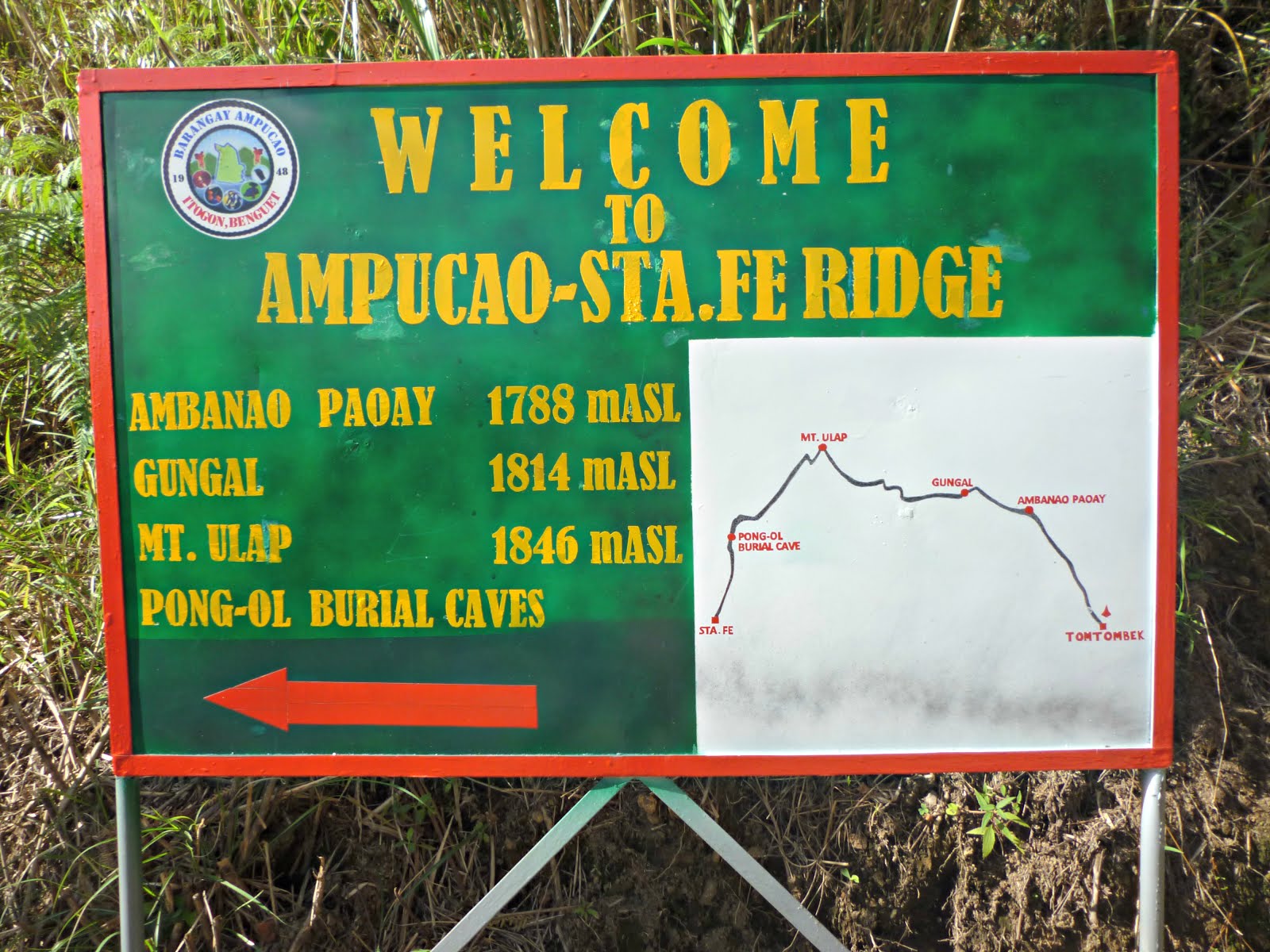
A welcoming signage in Mt. Ulap, revealing the regions of Mt. Ulap.
We started the hike at around 9:00 AM. The trek to the summit is divided into five stations, each of which has features unique for each station. The trail starts at Totombek, an uphill woodland region of Ulap. It is a thirty-minute continuous assault trail and one may start experiencing shortness of breath due to altitude. It's pretty much manageable though, and one would be welcomed by several pine trees and panoramic views of the Cordillera mountain along the trail.
On the trails of Totombek. 
Hello, pine trees! Stepping on one of the rock formations seen along Totombek.
The trail continues until it leads to Ambanao Paoay. According to locals, the word ambanao paoay means a bare piece of land with no trees attributed to the apparent grassy character of the region.
To the grasslands of Ambanao Paoay.
Cattles are of usual sight in this part of the mountain. One of the highlights of this part of the trail is the man-made rock tower installed by hikers on an region overlooking the mountains of Cordillera. According to the locals, the tradition of piling rocks emerged with the belief that the higher the tower is, the nearer you get to the keepers of the mountains, making your wishes come true. Though the same practice remains until today, these rocks have been one of the famous sights of Mt. Ulap.

Rocks, clouds and mountains.
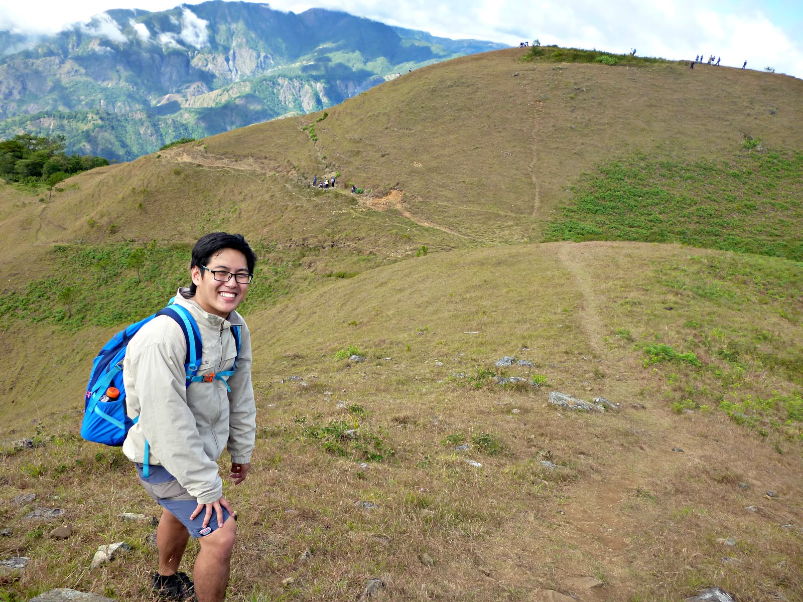
Now we can say that this selfie of my friend truly rocks. Yay!
After Ambanao Paoay, the trail commences with one-hour walk to Gungal Rock Formation, the rock formation that made the mountain famous for its picture perfect shots. Along the way, there are rocks similar to Gungal, though much smaller, are also picture-perfect.

Reaching new heights. Taking alternatives. One of the most breathtaking shots taken in Mt. Ulap.
Locals say that Gungal Rock Formation was an aftermath of the collapse of once a tall rock statue because of an earthquake. Extra precautions are needed when assaulting the rock formation as it is steep and can really be slippery.
At the Gungal Rock Formation with my hiking friends.

Got cotton candies on the background. Braving myself to stand at the edge of this majestic rock formation.
From Gungal, the summit can be achieved in an hour or less. The trail, though majority of which are assault, is gradual. From here, since the altitude gets higher, the sights become more remarkable. One will be rewarded by the panoramic views of Benguet and La Union, extending to Pangasinan, Tarlac, Nueva Vizcaya and Aurora, with sights of Mt. Ugo, Mt. Sto. Tomas, Mt. Cabuyao, Mt. Timbak, Mt. Tabayoc and Mt. Pulag from the summit. We arrived at the summit at 12:00PM.
Final assault to the summit.

Playful clouds on the background. Conquered Mt. Ulap!
From the summit, one can see how clouds start to play along the peaks of Mt. Ulap. We stayed for an hour before traversing to Sta. Fe. We actually witnessed how clouds travel to the summit at exactly 1PM. It was Mt. Ulap after all. From the summit, one can actually opt to backtrack the previous trail but a traverse trail will lead you to another destination in the mountain, the Pong-Ol Burial Caves. The descent trail is steep and continuous, but trail supports are installed. The burial caves can be accessed through a different trail and extra precaution is required as the trail is loose and slippery. There are three burial cave sites on the trail, each of which has legends and stories that are yet to be discovered. Though the identity and estimated age of those buried on the caves are still unknown, the locals believe that the mountain has more burial sites that are yet to be explored as well. We actually advise the guide to ask the elderly of the folklores about the mountain to enrich the culture of the mountain and share it as well to the hikers. Barangay protocol prohibits hikers from photographs of the burial caves and sites, which of course, we followed; however, some of the hikers seem to not understand and still took photos of the sacred artifacts of Mt. Ulap. Again, as I always emphasize, we always need to show respect not only to the people but to the protocols set by the officials. It is their way to preserve what they have and as visitors of the mountain, we should do our part in protecting these hidden treasures as well.

The trail ends in a hanging bridge to the community of Sta. Fe, where one can take a bath before proceeding to Baguio. From Baguio, one can opt to explore the city's rich night life and ride a bus bound to Manila afterwards, or go to Vigan or La Union for a side trip.

ITINERARY
Mt. Ulap (Ampucao-Sta. Fe Traverse) Dayhike
Day 0
10:00 PM
Assembly at Victory Liner Cubao. Take bus bound to Baguio City.
Day 1
06:00 AM
Arrival at Baguio City. Proceed to Petron Harrison.
06:15 AM
Take jeep bound to Philex Ridge.
07:00 AM
Arrival at Brgy. Ampucao. Proceed to barangay hall.
07:15 AM
Register at barangay hall. Secure guides.
07:30 AM
Proceed to jumpoff. Start trek.
08:30 AM
ETA Totombek.
09:30 AM
ETA Ambanao Paoay.
11:00 AM
ETA Gungal Rock Formation.
12:00 PM
Arrival at Mt. Ulap summit. Lunch. Explore area and viewpoints.
01:00 PM
Start descent to Brgy. Sta. Fe
02:15 PM
ETD Pong-ol Burial Caves
04:00 PM
ETA Brgy. Sta. Fe. Tidy up.
05:00 PM
ETD Brgy. Sta. Fe.
05:30 PM
ETA Baguio City. Explore area for side trip.
10:00 PM
Take bus bound to Manila
Day 2
04:00 AM
ETA Manila

SPECIAL NOTES

Transportation: Baguio City is accessible via public or private transportation; however, Brgy. Ampucao can only be accessed through jeepneys going to Philex Ridge. Bus fare going to Baguio City costs Php 455 as of 2016, while jeepney fare to Brgy. Ampucao costs Php 50. Based from experience, Philex Ridge-bound jeepneys only leave their terminal at Petron Harrison once the jeep is or almost full.

During peak season of hiking in Mt. Ulap, jeepneys and FX bound to Baguio wait at the exit point at Brgy. Sta. Fe. Though jeepneys coming from Philex Ridge or Ampucao passes through Brgy. Sta. Fe, they can really be seldom and arriving late at the exit point can be a problem. Usually, the last trip of jeepney passing though Sta. Fe arrives at 06:00 PM.

Registration, guides and porters: Individual environmental fee of Php 100 is collected at the barangay hall. Guide fees are fixed at Php 400 per day for a maximum of ten persons. Porter fees follow the same rate. Upon finishing the traverse, an additional Php 20 is collected in Brgy. Sta. Fe. The officials of Brgy. Ampucao strictly implements a no guide, no hike policy.

Hiking and camping notes:

  1. Cellular signals are sporadic along the trail.
  2. Do not be deceived by the cold weather. Majority of the trail is exposed to sun. Wear proper clothing and apply sunblock to protect yourself from ultraviolet rays.
  3. Do not attempt to climb Mt. Ulap when raining. Trail can be muddy and slippery. The weather in the mountain can also be unbearable during the rainy season.
  4. Camping sites are available in Mt. Ulap, specifically at the summit and at Ambanao Paoay.
  5. Remember that the locals consider Mt. Ulap as one of their sacred grounds. Observe proper LNT principles.
  6. Do not attempt to take photographs of the burial caves as it is prohibited by the local officials. Observe silence especially when passing through these sites as a sign of respect.
  7. There are no water sources along the trail.
  8. Altitude sickness and shortness of breathing may be experienced while hiking Mt. Ulap. Prepare accordingly.
Estimated budget: Php 1000 - Php 1500

Credits to Ivy Cadalzo and Kimberly Aspa for the photos.
Read More
Older Posts Home

About the blog

On seas, summits, rivers, mountains and different destinations across the world. This blog narrates the stories and experiences of a simple traveler who wants to mark his step in every part of the world.

Featured Post | Summiting 2015

Featured Post | Summiting 2015

Popular Posts

  • Hiking Chronicles: Talamitam-Apayang Traverse
  • Hiking Chronicles: Mt. Ulap
  • Hiking Chronicles: Mt. Daraitan

Blog Archive

  • ▼  2016 (12)
    • ▼  November (1)
      • Hiking Chronicles: Maysawa Circuit (Mt. Sa Pari - ...
    • ►  August (2)
    • ►  March (2)
    • ►  February (2)
    • ►  January (5)
  • ►  2015 (10)
    • ►  October (1)
    • ►  September (2)
    • ►  August (4)
    • ►  July (2)
    • ►  June (1)
Powered by Blogger.

Contact Us

Name

Email *

Message *

Copyright © The Nerdy Traveler | Powered by Blogger
Design by Flythemes | Blogger Theme by NewBloggerThemes.com